In a small town about 80 km (50 mi) north of Brussels, there is a single front door with two house numbers. One belongs to Belgium. The other belongs to the Netherlands. The international border runs straight down the middle of the door, and the house is officially Loveren 2 on one side of the line and Loveren 19 on the other.
This is Baarle-Hertog and Baarle-Nassau, the two towns that share the same town.
The arrangement comes from a series of medieval land swaps between the Lords of Breda and the Dukes of Brabant, traded back and forth across the 12th and 13th centuries until nobody could untangle who owned what. When Belgium broke away from the Netherlands in 1830 and the two new countries needed an actual border, the border followed the existing land titles. The titles were a mess. The border became a mess. It was formally fixed by the Treaty of Maastricht in 1843 (an earlier border-settlement treaty by the same name, not the famous 1992 one) and never cleaned up afterward.
Today there are 22 Belgian enclaves sitting inside the Netherlands. Seven of those Belgian enclaves contain smaller Dutch enclaves within them: counter-enclaves, pieces of the Netherlands inside Belgium inside the Netherlands. The largest Belgian piece covers most of the town center. The smallest enclave is a single field.
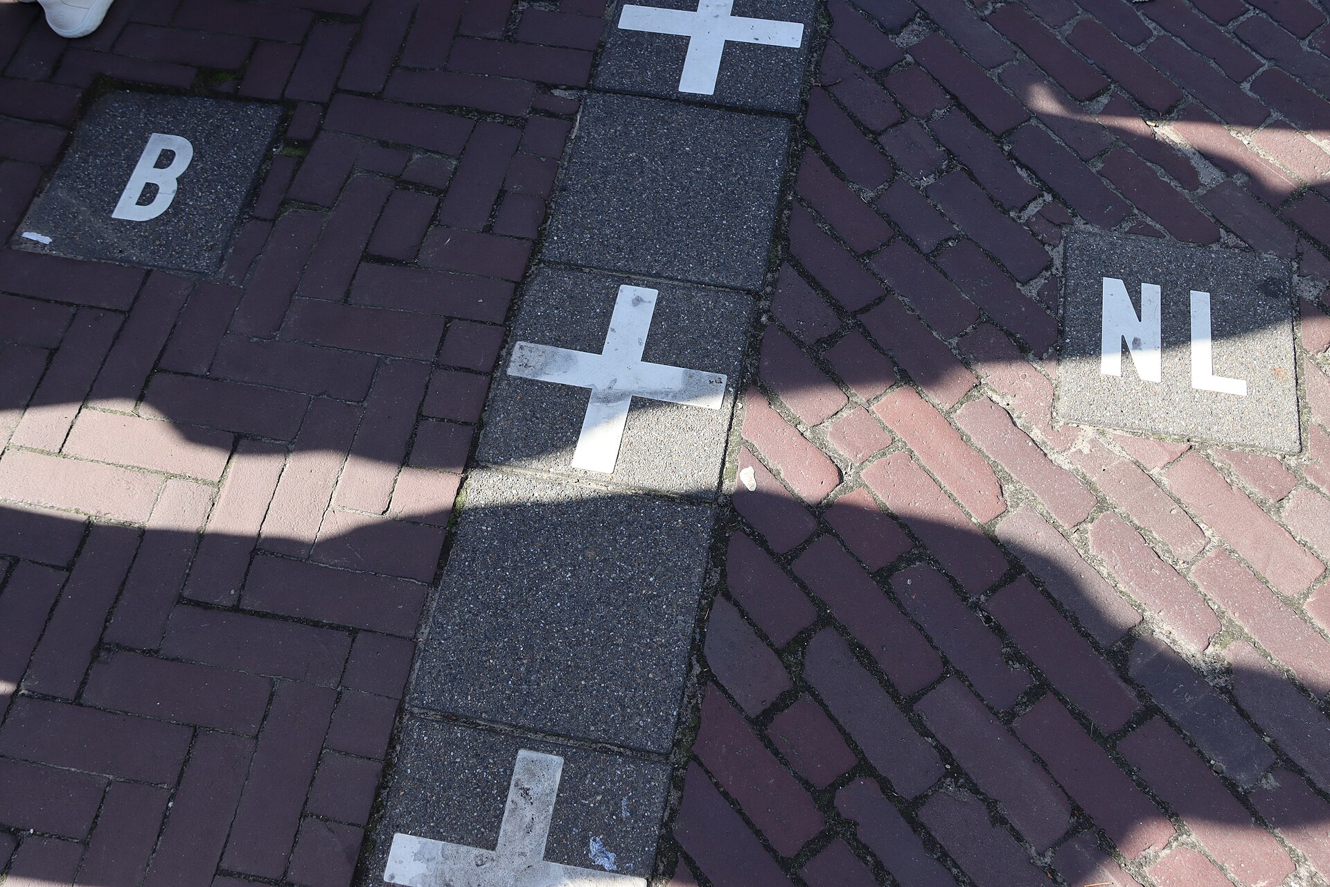
You can see the border in the ground. White crosses with the letters “NL” and “B” are set into the pavement of the main shopping street, looping through plazas, cutting under restaurant tables, crossing back and forth across the sidewalk. Buildings get bisected. The official enclave catalog notes one boundary that “runs through a house and three sheds.” Another bisects a liquor store loading dock, so crates loaded from one end are imported goods and crates loaded from the other end are domestic.
For most of the 20th century, this was a daily-life problem. Children went to school in whichever country their family was registered in, even when the school was a short walk away across an invisible line. Police could not cross the line to make an arrest. Postal services were two systems running through the same streets. Then Europe spent the second half of the century slowly turning two-country complications into not-complications. The Schengen Agreement abolished border checks in 1995. Both countries adopted the euro in 1999. The two towns now share restaurants, shops and an annual joint festival, with residents registering with whichever government they technically fall under.
The border still matters in quieter ways. Belgian and Dutch tax rates differ. Banking regulations differ. Store opening hours and product rules have, at various points, diverged in ways that affected one side of a doorway and not the other. The town councils run a joint planning office to handle the inevitable awkwardness.
Which is the strange answer to what the border has become. The arrangement started as a medieval bookkeeping accident. It survived two world wars, a Belgian revolution and the entire 20th century. And the moment Europe figured out how to make national borders not matter very much, the towns turned the accident into a tourist attraction. There is a café in Baarle where you can sit at one table in Belgium and the next table in the Netherlands, and the boundary between them is a strip of metal embedded in the floor.
Learn more: Whyte, Brendan, “En Territoire Belge et à Quarante Centimètres de la Frontière: An Historical and Documentary Study of the Belgian and Dutch Enclaves of Baarle-Hertog and Baarle-Nassau,” University of Melbourne School of Anthropology, Geography and Environmental Studies, 2004. https://minerva-access.unimelb.edu.au/handle/11343/39065